The Smart Wireless Mesh
An off-the-shelf mobile ad-hoc network with edge compute and IoT capabilities.
Background
In August 2021 the Bay Area Mesh (BAM) (née San Francisco Wireless Emergency Mesh/SFWEM) participated in the week-long Naval Postgraduate School (NPS) Joint Inter-agency Field Experiment 21-4 (JIFX). This event, held quarterly at two facilities in California, provides numerous environments for experimentation, including freshwater & saltwater tanks, an airfield, simulated cities and villages, and natural California hills & terrain. Every JIFX incorporates stakeholders from multiple different organizations across disciplines within the federal government, including defense, homeland security, and others.
BAM conducted several experiments in collaboration with the Fab Lab at California State University Bakersfield, Splunk & Orion Labs. Every experiment explored the capabilities of the Smart Wireless Mesh across a variety of different missions:
- Disaster Response (DR/DRO)
- Situational Awareness (SA) & Common Operating Picture (COP)
- Unmanned Systems (UxS) Command & Control (C2)
- Sensor Data Collection (ISR) & IoT
- Real-time multimedia communications & collaboration
For each of these missions the Smart Wireless Mesh was tested both for feasibility of conducting this type of mission, and the ability for the network to be field expedient or rapidly deployed within an austere environment.
Several novel capabilities were also uncovered over the course of the experiment week.
Collaborators
- Bobby Hartsock KJ6YOA, Fab Lab at California State University Bakersfield
- Vivian Richards, Splunk
- Greg Albrecht W2GMD, SFWEM & Orion Labs
Themes & Motivation
Experiments can be best categorized under the themes of:
- Hastily Formed Networks
- Unmanned Systems
- Situational Awareness
- Smart Team Communications
Hastily Formed Networks
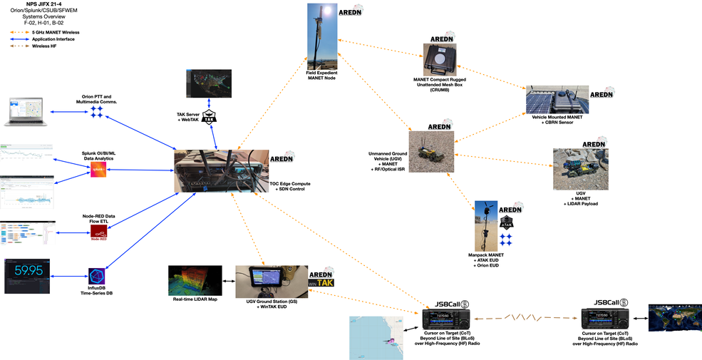
BAM utilizes commercial off-the-shelf (COTS) wireless networking equipment typically running the Amateur Radio Emergency Data Network (AREDN) firmware.
The AREDN firmware transforms COTS equipment into resilient auto-configuring mobile ad-hoc network (MANET) "Nodes" that provide high-speed wireless IP connectivity - including across multiple hops, support being hastily assembled (HFN) & dynamically redeployed. Regional AREDN networks have been deployed around the continental United States as well as abroad and represent both steady-state/always-on infrastructure & field-deployable systems.
Unmanned Systems
Piloting of an Unmanned Ground System (UGS) typically requires an IP based connection to a Ground Control Station (GCS). Similarly, UGS sub-systems like the video feed from an on-board camera or ISR systems require IP connectivity to a display or collection device. The reliance on wireless line-of-site radio signals can constrain the range of a UGS. Similarly, the reliance on static or point-to-point IP routing between a UGS & GCS can constrain the ability of the IP network to recover from a routing fault.
AREDN can provide a UGS with IP networking and back-haul on-the-move, allowing both remote piloting and video streaming between the UGS & GCS. Additionally, because each UGS was also itself a AREDN node, every UGS is also able to extend the range of the existing network. Combined with another UGS this allows a multi-hop ‘swarm’ like system were multiple different UGS can extend or augment the existing network in real-time.
Situational Awareness
Situational Awareness (SA) platforms like ATAK & WinTAK can be configured to share data via a local-only IP network, or pass data out to another network segment or to a TAK Server. AREDN allows ATAK users on-the-move to be continuously connected to other ATAK users, or can be configured to backhaul SA traffic to forward-deployed or centralized TAK Servers.
The RedTAK “Tactical Data Switchboard” or “Tactical ETL” was developed using Node-RED. RedTAK allows SA data like Cursor on Target (CoT), as well as operational data from Mesh nodes, and piloting data from the UGS, to be streamed into Splunk for collection & processing through machine learning.
The ability to collect both SA and operational data from participants in the Smart Wireless Mesh lends itself to the use of machine learning (ML) to make predictions about changing network and end-user (or end-device) conditions. For example, a signal strength reading from a mesh radio can indicate an upcoming Loss of Signal (LoS) event, which is critical information to the pilot of a GS. Splunk and Splunk ML allow for the collection of and learning from all of this data. Splunk also allows for the input and processing of novel data, which can be used to measure user inputs, for example a Damage Assessment (DA) report sent via smartphone application, or spoken aloud through a PTT platform like Orion.
Smart Team Communications
Smart Team and group communications systems are equipped not-only to facilitate real-time messaging between disparate users, but act on those messages at a System level.
Given a user engaging in team collaboration at various "bandwidths" both physiologically and as a measure of information throughput, can a Smart Team Communications component of a Smart Wireless Mesh act on an end-users message metadata and provide a communications force multiplier. Can this Smart Team Communications platform present operational data to other organizational units or command?
Capabilities & Areas of Interest
Several proof-of-concepts and capabilities were tested at JIFX, with novel capabilities developed on-site and in ad-hoc collaboration with other JIFX participants & stakeholders. These capabilities centered around the themes of: Unmanned Systems, mobile on-the-go connectivity, edge compute, sensors/IoT, ISR & field expedience.
Areas of Interest:
- Unmanned Ground System (UGS) Command, Control (C2) & Communication (C3) using COTS & Open Source
- Using Node-RED as a tactical data transformation backplane - RedTAK: Tactical ETL
- Real-time UGS & MANET analytics using Splunk Enterprise & Splunk Machine Learning Toolkit. [TK]
- Situational Awareness (SA), C2, ISR & operational data analysis using Splunk. [TK]
- Cross-platform messaging based SA. [TK]
Proof of Concepts:
- FEM: Field Expedient Mesh
- MoW: Mesh on Wheels: Portable Smart Wireless Mesh node with edge compute, data transformation & sensor capability.
- MOHO: Mesh On, Head Out
- HAMPR: Human Attached Mesh Portable Radio
- CRUMB: Compact Rugged Unattended Mesh Box
Conclusions
Using commercial off-the-shelf hardware & open-source software, it is possible to stand-up a field expedient Smart Wireless Mesh using AREDN. This Smart Wireless Mesh provides unmanned systems command & control, group communication support, real-time sensors/IoT, and SA or ISR applications. Standards-based network end-points can be used immediately, and others integrated rapidly using Node-RED. Integration with Smart Team Communications platforms like Orion and operational intelligence platforms like Splunk enabled expedient knowledge and SA propagation to all users of the Smart Wireless Mesh.
Novel capabilities tested at JIFX:
- UGS C2 and C3 over AREDN MANET using multiple fixed or moving hops, including other UGS.
- AREDN MANET extension using UGS.
- UGS & MANET using COTS & Open Source.
- UGS-based, MANET-connected, sensor & ISR Platform using COTS & Open Source.
- Real-time UGS & MANET analytics using Splunk Enterprise and Splunk Machine Learning Toolkit.
Experiment Reports
Details
Data
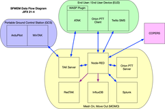
Operational data was collected from UGS C2, mesh radios and ATAK clients. During experimentation several data collection sources (or destinations) were reconfigured in-the-field using using RedTAK. RedTAK was configured to forward data to both Splunk & InfluxDB, with SA data mirored to COPERS.
Several remote systems that were capable of full-duplex data transfer were also integrated into RedTAK, allowing the RedTAK system to transform any real-time SA data into a format compatible with another remote system - allowing each to render a COP in their native representation.
Systems like Orion & Twilio that were capable of sending, receiving and understanding human voice, typing and multimedia messaging were able to interact through either their own, or a native CoT channels.
Splunk
Splunk collected all operational & SA data originating from and passing through the experiments at JIFX. Early operational questions could be quickly answered with Splunk. All data passing through RedTAK could be transformed and indexed by Splunk. This data pipeline allow a wireless RF anomoly enountered early in experimentation with our UGS to be quickly isolated. Using a Splunk Alert with RedTAK allowed us to delivery an instant LoS condition alert to the GCS.
Of interest to our collaboration with Splunk was to test the ability to act as a data force multiplier for DSCA operations, particular within the disaster response and evaucation planning missions.
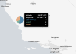
Using ATAK with the WASP Plugin, rescuers were able to populate a damage assessment dashboard within Splunk in real-time. For users operating in a heads-up mode, Orion was used to understand PTT conversations between rescuers. Finally, for users with limited message capability within LTE denied environments, SMS text messages with damage assessment reports & locations could be sent & received by Twilio.
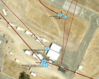
A procedure was developed on-site to transform ArduPilot Mission Planner UGS location positioning data into Cursor on Target, a format used by Splunk, ATAK and others. In this procedure, WinTAK running on the GCS computer was used as a NMEA to CoT gateway. Effort was made to analyze real-time UGS operational data in Splunk by utilizing a Mavlink decoder with limited success.
Data & SA Capabilities
Several novel capabilities were developed during experimentation.
- Sending SA data to COPERS. This was the first time we've intereacted with this system. Using RedTAK we were able to establish a bidirectional data connection with COPERS, allowing us to send SA data to, as well as receive SA data from all other users of COPERS (including other experimenters).
- Collecting & learning AREDN sysinfo.json telemetry data. Early experimentation showed an emerging wireless RF anomoly. A RedTAK flow was created to search for & collect AREDN sysinfo.json data from all MANET nodes - forwarding all collected data to Splunk. A hastily constructed discovery method allowed new MANET participants to be queried, or old ones pruned.
- Sending SA data to Splunk. The n-dimensional nature of SA data, relying on both time and 3D space, allow index, search and machine learning across all dimensions using Splunk. Indexed geographical data can be displayed using a Splunk map dashboard, and temporal data can be analyized in real-time by a human or using a Splunk ML process.
An attempt was made to integrate Mavlink data into both Node-RED & Splunk with limited success. Further research is recommended in this area.


